


Le Cheylard St Martin AR

pidjam
User
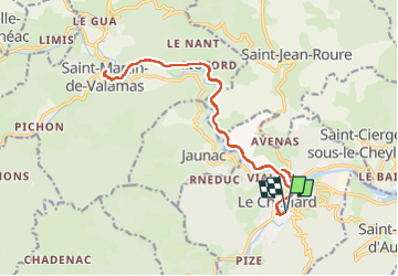

Length
19.3 km

Max alt
569 m

Uphill gradient
429 m
Km-Effort
25 km

Min alt
425 m

Downhill gradient
426 m
Boucle
Yes
Creation date :
2022-07-29 06:52:22.805
Updated on :
2022-07-29 12:46:46.297
5h50
Difficulty : Medium

FREE GPS app for hiking
 SityTrail
IGN / Geographical institutes
SityTrail Plus
The world is yours!
About
Trail Walking of 19.3 km to be discovered at Auvergne-Rhône-Alpes, Ardèche, Le Cheylard. This trail is proposed by pidjam.
Positioning
Country:
France
Region :
Auvergne-Rhône-Alpes
Department/Province :
Ardèche
Municipality :
Le Cheylard
Location:
Unknown
Start:(Dec)
Start:(UTM)
612516 ; 4973609 (31T) N.
Comments